Updated November 25, 2025
Background
The American Revolution brought much change to Virginia, including a new state government. Because of the upheaval, no grants were made between 1775 and 1779, when an act establishing the Land Office was passed. A register, elected by the General Assembly, administered the distribution of Virginia’s waste and unappropriated lands. This system remained in effect until the mid-twentieth century. Under the act a person could purchase as much vacant land as desired by payment to the treasurer of a fee—£40 for each one hundred acres, later changed to dollars and cents. The treasurer issued a receipt for this payment, which was presented to the state auditor, who in turn issued a certificate noting the amount of land to which the person was entitled. The certificate was then taken to the register of the Land Office, who issued a warrant, called a treasury warrant, authorizing any surveyor to lay off the quantity of land specified. Treasury warrants contain the name of the warrantee, the amount of acreage and money paid for the warrant, the warrant number, to whom the land was ultimately granted, the reference to the grant book and page number, and the name of the county in which the land was granted.
The process continued with the warrantee presenting the warrant to the county surveyor where the land was located. The land was surveyed and the warrantee returned the warrant, survey, and other related papers to the Land Office. Six months were allowed for caveats (or objections) to the survey. If none were entered, the plat and certificate of survey were recorded, the grant was signed by the governor and recorded, and the original delivered to the grantee.
At any time in the grant process after the treasury warrant was purchased, the purchaser could assign (sell) the right to part or all of the land described in the warrant. These assignments and other papers related to individual grants after 1779 are known as plats and certificates.
The Land Office Act of 1779 also provided for the awarding of bounty land for Revolutionary War military service. This process did not become operative until the end of the war in 1783, but bounty land promised in 1763 for French and Indian War service by soldiers in the two Virginia Regiments was finally allotted in 1779–1780. Soldiers or their heirs gave proof of service in their local county courts, and a bounty warrant was issued by the Land Office. A list of soldiers who received land for French and Indian War service is found in Lloyd D. Bockstruck, Virginia’s Colonial Soldiers.
The same act that allowed bounty land for French and Indian War service also allowed the settling of land claims outstanding from the colonial period to 1779, especially for land that had been settled but for which no legal title had been made. Some of this land was in the District of West Augusta, an area between modern-day West Virginia and Pennsylvania, and also on the western frontier of Virginia. Persons who had settled on unclaimed land prior to 1778 were eligible to obtain preemption (prior settlement) certificates for four hundred acres, and up to one thousand acres of additional land. Commissioners were appointed to apportion the land.
The process for receiving land for Revolutionary War service required several steps. Soldiers (or their heirs) were eligible for land if they served in the Continental Line, State Line, or State Navy for three years or longer, or if they died in service. After submitting proof of their unit, rank, and length of service (known as the bounty warrant), the applicant was issued a numbered land office military certificate. This in turn was followed by the issuance of a numbered military land warrant, which was presented to the surveyor of the Virginia Military Lands in what are now Ohio and Kentucky, where the lands were located. (At this time the warrantee could also file an entry with the county clerk for specific acreage to be set aside for surveying, and some counties retain entry books among their records.) A grant conferring legal title was then issued by the state. At any point in the process after service was proved, the land could be assigned (sold) to someone else.
Overview
The above Warrant David Gilliam receives lies on the Branches of the Holloday River, southside of the Buckingham Road. This land is bound by Mr. Joseph Brown, William Morriss, Crouches, Richard GILLIAM, James Walker, and David McCormack. This places David squarely in relation to Richard Gilliam of Buckingham and David McCormick. It should be noted that David Gilliam’s eldest son is named Richard.
A grant for David McCormick reveals that one of his bounds includes Epaphroditus Gilliam:
David McCormack, 282 acs. 6 Apr 1769
On the head br. Of Willis’s Rive. Adj. His own line, Lambeth Blackbourn & Epaphroditus Gilliam. £1.S10.
Cavaliers and Pioneers, Volume VII, page 159
The McCormicks and Epaphroditus Gilliam are both mentioned in the Bible of Richard Gilliam.
David Gilliam leaves a Will in Scott County.
8 Jun 1795
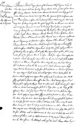
James Wood, Esquire, Governor of the Commonwealth of Virginia, to all to whom these presents shall come Greeting. Know ye that by virtue of part of two Land Office Warrants. Number twelve thousand, two hundred and thirty eight and sixteen thousand, seven hundred and sixty three, there is granted by the said Commonwealth unto David GILLIAM a certain tract or parcel of land containing four hundred and sixty acres by survey bearing date the eighth day of June one thousand seven hundred and ninety five lying and being in the County of Buckingham on some of the Waters of the Holladay River and south side of the Buckingham Road joining the lines of Mr. Joseph Brown, William Morriss, Crouches, Richard GILLIAM, James Walker, David McCormack, and Olive Branch and is bounded as followeth to wit:
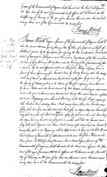
Beginning at pointers a corner between Olive Branch and Joseph Brown, thence on Brown’s line, north twenty and a half degrees east fifty poles to a pine, north ten degrees, east ninety nine poles crossing a branch of Holloday River to a pine, south eighty three degrees east eighteen poles crossing another fork of the aforesaid branch to a pine, south five degrees, east eight poles to a pointer South seventy five degrees east one hundred and eight poles to pointers in William Morriss’s line, thence along the same due east seventy poles to pointers in Couches line and with it north seventeen and a half degrees west one hundred and eighty four poles to pointers in Richard GILLIAM’s line and along it south twelve and a half degrees West twelve poles to pointers north eighty seven degrees west eighty six poles to pointers due North fifty eight poles to pointers; thence off a new line, north twenty degrees west thirty one poles crossing the Burds [word is underlined in original] Road to a post oak, south seventy five degrees west one hundred an d twenty five poles to a large pine in the Edge of the aforesaid road, south forty degrees west, one hundred and ten poles to a large pine south eighty one degrees west, fifty two poles to pointers in James Walker’s line, thence along the same south thirty degrees east seventy eight poles to pointers due south fifty eight poles to pointers in David McCormacks line thence along the same, south seventy four degrees east forty six poles to pointers in Olive Branches thence along the south forty degrees east one hundred and forty three poles to the first station with its appurtances to have and to hold the said tract or parcel of Land with its appurtances to the said David GILLIAM and his heirs forever, whereof the said James Wood, Esquire, Governor
Sources
- Land Office Grants No. 39, 1797-1798, p. 135; Reel 105